The aim of this project is to develop a long-range Unmanned Aerial Vehicle for high-Quality Magnetic Surveying (UAV-QMS), which is globally deployable, even in complex terrains or from ships, and capable of collecting high signal-to-noise ratio data safely and with >60% reduced costs compared to heliborne surveys.
High-quality magnetic surveying is used mainly for natural resources exploration (minerals, oil & gas, geothermal energy) and for finding unexploded bombs (or ‘Unexploded Ordnance’ (UXO), in relation to cable laying for offshore wind farms, commercialization of military test sites, or humanitarian projects.
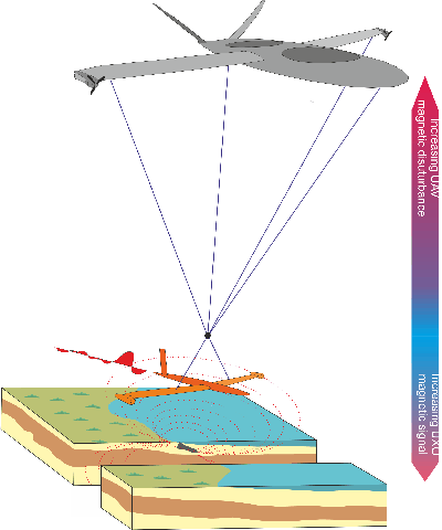
Critical to magnetic surveying is that measurements can be done close to ground, at minimum noise levels and with precise positioning. Today, such surveys are carried out often from helicopters using a so-called magnetometer bird or from ground. Heliborne surveys are expensive and logistically challenging, especially in remote areas, and ground surveys are often time consuming and incomplete and – in the case of UXO surveys – linked with high risk. In addition, heliborne surveying relies on highly skilled pilots which makes it inflexible.
In other words, efficient mineral exploration in places like Greenland, as well as global clearance of unexploded bombs, are impeded by existing survey methods.
This project will integrate (hardware & software-wise) the vertical take-off & landing hybrid Smart UAV platform from Sky-Watch with a new patent pending UAV- compatible magnetometer bird. The UAV-QMS is the first hybrid fixed-wing and multirotor UAV designed specifically for long-range autonomous magnetic surveying with a bird, which provides increased signal-to-noise ratio data.
The UAV-QMS will have Vertical Take-Off and Landing (VTOL) and hovering capabilities, allowing it to be launched from ships or in mountains and to closely follow the surface, even in uneven terrain. Being equipped with Cesium magnetic sensors, the UAV-QMS will provide a novel magnetic surveying platform (incl. fully integrated state-of-the art magnetic and GNSS processing software) that can replace most heliborne and ground platforms. It will also surpass existing UAV surveying platforms, which rely on pure fixed-wing or multirotor setup.
The project will comprise three main tasks:
- Development & integration of the UAV-compatible bird
- Modification of the Smart UAV
- Airborne testing
Initial testing will focus on the need to clear mines from World War II, before laying power cables to new offshore wind turbines. It is assumed that the number of unexploded mines from World War II hidden in the sea and on land is around 5,000. And according to the UN, more than 110 million unexploded devices exist worldwide, killing over 15,000 people annually. Besides the human risks, unexploded devices pose a threat to the local environment and to operations, installations and personnel, e.g., during constructions of wind farms.
The magnetometer drone will furthermore be tested in the mountains of Greenland, where it may have an impact on the search for mineral deposits or military waste, and it will also be tested from a vessel in relation to its ability to detect large mines in deeper waters. In both cases, the drone’s ability to take off and land vertically is significant.
The project has received DKK 11 million from Innovation Fund Denmark and has a total budget of DKK 16 million. The project is scheduled to run from 2017-2021 and will fund 2 PhD students. CERE faculty member Senior Researcher Arne Døssing, DTU Space, is grantholder and PI.
External project partners are Sky-Watch, Geo, and DONG Energy, and The Royal Danish Navy’s Explosive Ordnance Demolition Group